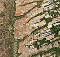
Fail:Central-eastern Brazil, by Copernicus Sentinel-2A satellite.jpg

Kandungan laman tidak disokong dalam bahasa lain.
Daripada Wikipedia, ensiklopedia bebas.

Fail asli(11,458 × 10,980 piksel, saiz fail: 94.42 MB, jenis MIME: image/jpeg)

Fail ini dari Wikimedia Commons dan mungkin digunakan oleh projek lain. Penerangan pada laman penerangan failnya di sana ditunjukkan di bawah.

Ringkasan

Warning The original file is very high-resolution. It might not load properly or could cause your browser to freeze when opened at full size.
Keterangan
English: Central-eastern Brazil, by Copernicus Sentinel-2A satellite.

Here we can see a large, flat plateau blanked with fields benefiting from rich soils and an apparent abundance of water, before falling off into a green, hilly valley (left). The straight lines in the image are roads, such as the highway running in a nearly straight line from the centre-top to bottom of the image.

The area is particularly known for soybean production. The country’s soybean output has increased by more than 3000% since the 1970s, and Brazil is the second largest global producer of soybeans after the US.

Other crops in this area include corn, coffee and cotton.

A distinctive feature in this image is the circles – mainly at the centre. These shapes were created by a central-pivot irrigation system, where a long water pipe rotates around a well at the centre of each plot. The varying colours show different types of crop, or different stages of growth.

The two-satellite Sentinel-2 mission is designed to monitor changing lands, including crop type and health. While the first satellite has been in orbit since 2015, its Sentinel-2B twin was launched on 7 March. Together, the satellites will provide new images of Earth’s land surfaces every five days.
Tarikh
Sumber http://www.esa.int/spaceinimages/Images/2017/04/Central-eastern_Brazil
Pengarang ESA / Copernicus Sentinel-2A

Featured imej

Wikimedia Commons

Fail ini merupakan gambar pilihan di Wikimedia Commons (Gambar Pilihan) dan ia dianggap salah satu imej terbaik.

Jika anda mempunyai imej dengan mutu yang serupa dan boleh diterbitkan di bawah lesen hak cipta yang bersesuaian, pastikan anda memuat naik, menanda dan mencalonkan imej tersebut.

Perlesenan

w:ms:Creative Commons
pengiktirafan perkongsian serupa
Anda bebas:
  • untuk berkongsi – untuk menyalin, mengedar dan memindah hasil kerja
  • untuk mencampur semula – untuk menyesuaikan karya
Di bawah syarat berikut:
  • pengiktirafan – Anda mesti memberi penghargaan yang berpatutan, bekalkan pautan ke lesen, dan tunjukkan jika perubahan telah dibuat. Anda boleh lakukannya dalam sebarang cara yang munasabah, tetapi bukan dalam sebarang cara yang mencadangkan pemberi lesen mengendors anda atau penggunaan anda.
  • perkongsian serupa – Jika anda mengubah, adun semula, atau menokok tambah bahan, anda mesti menyebarkan sumbangan anda di bawah lesen yang sama atau serasi dengan yang asal.
Fail ini, yang pada asalnya dihantar ke http://www.esa.int/spaceinimages/Images/2017/04/Central-eastern_Brazil, telah disemak pada 6 May 2017 oleh penyemak Daphne Lantier, yang mengesahkan bahawa ia telah didapati di sana di bawah lesen yang dinyatakan pada tarikh itu.
© This image contains data from a satellite in the Copernicus Programme, such as Sentinel-1, Sentinel-2 or Sentinel-3. Attribution is required when using this image.
Pengiktirafan: Contains modified Copernicus Sentinel data 2016

The use of Copernicus Sentinel Data is regulated under EU law (Commission Delegated Regulation (EU) No 1159/2013 and Regulation (EU) No 377/2014). Relevant excerpts:


Financial conditions

Free access shall be given to GMES dedicated data [...] made available through GMES dissemination platforms [...].

Conditions regarding use

Access to GMES dedicated data [...] shall be given for the purpose of the following use in so far as it is lawful:

  1. reproduction;
  2. distribution;
  3. communication to the public;
  4. adaptation, modification and combination with other data and information;
  5. any combination of points (a) to (d).

GMES dedicated data [...] may be used worldwide without limitations in time.

Conditions regarding information to be given by users
  1. When distributing or communicating GMES dedicated data [...] to the public, users shall inform the public of the source of that data and information.
  2. Users shall make sure not to convey the impression to the public that the user’s activities are officially endorsed by the Union.
  3. Where that data or information has been adapted or modified, the user shall clearly state this.
Absence of warranty

GMES dedicated data and GMES service information are provided to users without any express or implied warranty, including as regards quality and suitability for any purpose.

Captions

Add a one-line explanation of what this file represents

Items portrayed in this file

menggambarkan

8 Ogos 2016

media type Inggeris

image/jpeg

860b7590190d304c92c5b201af7f153b579ee130

99,007,576 bait

10,980 piksel

11,458 piksel

Sejarah fail

Klik pada tarikh/waktu untuk melihat rupa fail tersebut pada waktu itu.

Tarikh/WaktuGambar kenitUkuranPenggunaKomen
semasa10:45, 12 Jun 2020Gambar kenit bagi versi pada 10:45, 12 Jun 202011,458 × 10,980 (94.42 MB)The RedBurnColor balance
22:03, 5 Mei 2017Gambar kenit bagi versi pada 22:03, 5 Mei 201711,458 × 10,980 (92.43 MB)Yannc:User:Rillke/bigChunkedUpload.js: HR from TIFF, 98% compression
20:24, 5 Mei 2017Gambar kenit bagi versi pada 20:24, 5 Mei 20171,920 × 1,840 (3.84 MB)YannTransferred from http://www.esa.int/var/esa/storage/images/esa_multimedia/images/2017/04/central-eastern_brazil/16900171-1-eng-GB/Central-eastern_Brazil.jpg

Tiada laman yang menggunakan fail ini.

Penggunaan fail sejagat

Fail ini digunakan oleh wiki-wiki lain yang berikut:

Metadata